Fazal Muhammad Gujjar Shaheed
Fazal Muhammad Gujjar Shaheed
Fazal Muhammad Gujjar was born in Village Dhok Kasib, Mandi Bahauddin and got Shadat in the war of 1971.


Fazal Muhammad Gujjar was born in Village Dhok Kasib, Mandi Bahauddin and got Shadat in the war of 1971.
Muhammad iqbal shaheed jhulana
Muhammad Iqbal Naik was born in Jhulana village of Mandi Bahauddin. He got Shadat on 26th July, 2004 in Turbat Balochistan against terrorist.
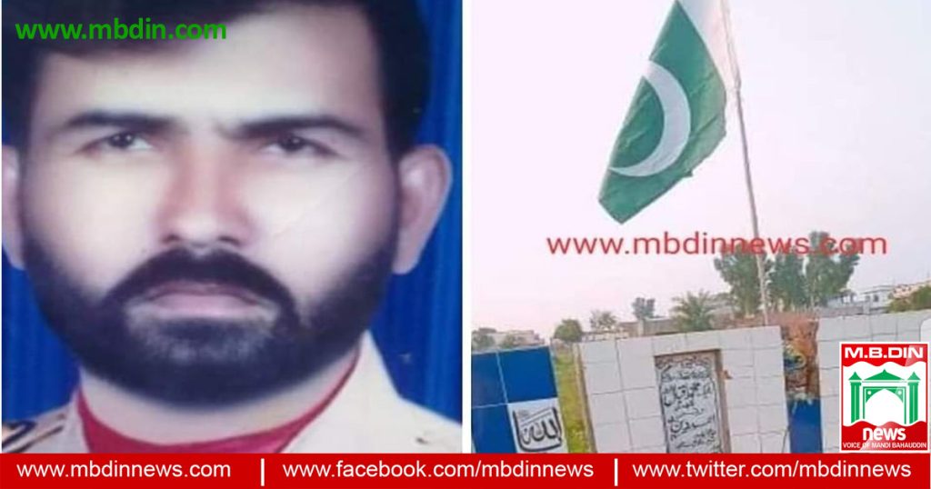
Mudassir Riaz Shaheed was born on 2nd February 1990 in village Daffar Mandi Bahauddin. He passed his Matric from govt High School Chak No. 26 on 1st August 2088.
In September 2009, he join Pakistan Army and take part in Valley Teera, Khyber Agency on March 2010 against terrorist in operation.
In February 2013, he joined 2 Baloch Rajment and Siachin operation and was awarded by Glacier Siachin.
In December 2014, he joined 16 Baloch Rajment and take part in Janubi Waziristan against terrorist.
In May 2018, he joined 50 Baloch Rajment and take part in Awaran Operation. He got Shadat on 2nd August, 2018 in Awaran Operation.
He was buried on 3rd August, 2018 in his hometown daffer graveyard with honor.
Muhammad Azam Tarar Shaheed were born in village Dhala tehsil Phalia district Mandi Bahauddin. He was a very good Kabaddi Player, He was son of Nazar Muhammad Tarar who were also famous Kabaddi Player.
He got Shadat on 16th December, 2007 4:20 AM near Mand in Sawat during operation against terrorist. He was buried on 17th December, 2007 in his hometown Dhala Sharif tehsil Phalia with honor and respect.
Caption Asim Iqbal Shaheed was born on 25th March, 1980 in Phalia and got shadat on 4th May, 2009 at Sawat Operation. May Allah grant him with high ranks in Jannah

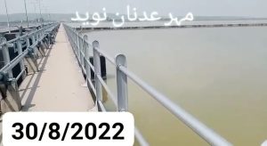
Rasul Barrage Mandi Bahauddin is a barrage on the River Jehlum between Jhelum District and Mandi Bahauddin District of the Punjab province of Pakistan. It is situated 72 km downstream of Mangla Dam. wikipedia
Today water level at Rasul Barrage MBDIN is given below.
Date 01-09_2022
Time 12:00 pm
Head Rasul water level on 31-08-2022
Head Rasul water level on 30-08-2022
Head Rasul water level on 29-08-2022
We request you all not to listen to false rumours. There is no danger of flooding in the Jhelum river yet. All people, please pray for Allah Almighty to protect you. By the way, the people living on the banks of the Jhelum river must take precautionary measures. There is also a new order from the government of Pakistan to follow it. I am present for information about water in Jhelum river. (Mahar Adnan Naveed 01.09.2022)
Rasul Barrage showing main barrage and offtake canals Data provided for this study (IRSA 2015) include? the crest level of the under-sluice bays is 212.9 m (698.5 ft) above mean sea level;? the crest level of the main weir is 214.3 m (703 ft) above mean sea level; ? the upstream floor level is 211.8 m (695 ft) above mean sea level; ? no storage capacity information was available for this study, however a volume of approximately 51 km 3 at operational water level has been inferred from aerial photography; ? there are 42 standard bays on the main weir 18.288 m (60 ft) across; ? there are 6 under-sluice bays, 18.288 m (60 ft) across; ?
The maximum design discharge for the barrage is 24069 m 3 /s (850,000 ft 3 /s) at 218.2 m (716 ft) above mean sea level; and ? historic water level time series for Rasul (2001-2013) indicates that barrage levels are maintained at approximately 219.151m (719 ft) for most of the year, except for an annual cleaning period in early January. Water level time series and an average weekly pattern derived from this dataset are shown in Figure 29. The 10 daily pattern is used in the IRSM as the operational water level target for the barrage.
Electricity and light load shedding schedule in mandi bahauddin
GEPCO Mandi Bahauddin has issued a schedule of power outages in Mandi Bahauddin for Straining of New HT lines Jhulana Feeder and Al Asar Mall and also Jamering Bandinging & Shifting of Load from September 2022 to onwards.
Mandi Bahauddin (MBDN News 1 September, 2022) According to the schedule issued by GEPCO, the light of 4 Feeds of 132KV Grid Station of Mandi Bahauddin will be closed. The light of Complex Feeder, Crystal Feeder, City Feeder and Wasu feeder will be off on 1st September, 5, 8, 12, 15, 19, 22, 26 and 29 September 2022 from 9AM to 15PM.
| GEPCO Load Shedding Schedule Mandi Bahauddin September 2022 | ||||
| Sr. No. | Name of Grid Station | Name of Feeder | Date | Time |
| 1 | 132 KV Mandi Bahauddin | Complex Crystal City Wasu |
01-09-2022 | 09:00 to 15:00 |
| 2 | 05-09-2022 | |||
| 3 | 08-09-2022 | |||
| 4 | 12-09-2022 | |||
| 5 | 15-09-2022 | |||
| 6 | 19-09-2022 | |||
| 7 | 22-09-2022 | |||
| 8 | 26-09-2022 | |||
| 9 | 29-09-2022 | |||
| 10 | 132 KV Mandi Bahauddin | Canal Gurrah Katchery Phalia Road Sufi City Shah Taj Khewa |
12-09-2022 | 09:00 to 15:00 |
| 11 | 15-09-2022 | |||
| 12 | 19-09-2022 | |||
| 13 | 22-09-2022 | |||
| 14 | 26-09-2022 | |||
| 15 | 29-09-2022 | |||
| 16 | 132 KV Kuthiala Sheikhan | Gojra Rukkan |
03-09-2022 | 09:00 to 15:00 |
| 17 | 06-09-2022 | |||
| 18 | 10-09-2022 | |||
| 19 | 13-09-2022 | |||
Also read this: GEPCO Light Schedule In Mandi Bahauddin 2022 June
Similarly the light of 7 Feeds of 132KV Grid Station of Mandi Bahauddin will be closed. The light of Canal Feeder, Gurrah Feeder, Katchery Road Feeder, Phalia Road Feeder, Sufi City Feeder, Shah Taj feeder and Khewa feeder will be closed on 12 September, 15, 19, 22, 26 and 29 September 2022 from 9AM to 15PM.
Similarly the light of 2 Feeds of 132KV Grid Station of Kuthiala Sheikhan will be closed. The light of Gojra Feeder and Rukkan Feeder will be closed on 3 September, 6, 10 and 13 September 2022 from 9AM to 15PM.

Rasul Barrage Mandi Bahauddin is a barrage on the River Jehlum between Jhelum District and Mandi Bahauddin District of the Punjab province of Pakistan. It is situated 72 km downstream of Mangla Dam. wikipedia
Today water level at Rasul Barrage MBDIN is given below.
Date 31-08_2022
Time 09:00 am
Head Rasul water level on 30-08-2022
Head Rasul water level on 29-08-2022
We request you all not to listen to false rumours. There is no danger of flooding in the Jhelum river yet. All people, please pray for Allah Almighty to protect you. By the way, the people living on the banks of the Jhelum river must take precautionary measures. There is also a new order from the government of Pakistan to follow it. I am present for information about water in Jhelum river. (Mahar Adnan Naveed 31.08.2022)
Rasul Barrage showing main barrage and offtake canals Data provided for this study (IRSA 2015) include? the crest level of the under-sluice bays is 212.9 m (698.5 ft) above mean sea level;? the crest level of the main weir is 214.3 m (703 ft) above mean sea level; ? the upstream floor level is 211.8 m (695 ft) above mean sea level; ? no storage capacity information was available for this study, however a volume of approximately 51 km 3 at operational water level has been inferred from aerial photography; ? there are 42 standard bays on the main weir 18.288 m (60 ft) across; ? there are 6 under-sluice bays, 18.288 m (60 ft) across; ?
The maximum design discharge for the barrage is 24069 m 3 /s (850,000 ft 3 /s) at 218.2 m (716 ft) above mean sea level; and ? historic water level time series for Rasul (2001-2013) indicates that barrage levels are maintained at approximately 219.151m (719 ft) for most of the year, except for an annual cleaning period in early January. Water level time series and an average weekly pattern derived from this dataset are shown in Figure 29. The 10 daily pattern is used in the IRSM as the operational water level target for the barrage.
Rasul Barrage Mandi Bahauddin is a barrage on the River Jehlum between District Jhelum and District Mandi Bahauddin of the Punjab province of Pakistan. It is situated 72 km downstream of Mangla Dam. wikipedia
Head Rasul Water level today is given below.
Date 30-08-2022
Time 13:00
Head Rasul water level on 29-08-2022
We request you all not to listen to false rumors. There is no danger of flooding in the Jhelum river yet. All people, please pray for Allah Almighty to protect you. By the way, the people living on the banks of the Jhelum river must take precautionary measures. There is also a new order from the government of Pakistan to follow it. I am present for information about water in Jhelum river. (Mahar Adnan Naveed 30.08.2022)
Rasul Barrage showing main barrage and offtake canals Data provided for this study (IRSA 2015) include? the crest level of the under-sluice bays is 212.9 m (698.5 ft) above mean sea level;? the crest level of the main weir is 214.3 m (703 ft) above mean sea level; ? the upstream floor level is 211.8 m (695 ft) above mean sea level; ? no storage capacity information was available for this study, however a volume of approximately 51 km 3 at operational water level has been inferred from aerial photography; ? there are 42 standard bays on the main weir 18.288 m (60 ft) across; ? there are 6 under-sluice bays, 18.288 m (60 ft) across; ?
The maximum design discharge for the barrage is 24069 m 3 /s (850,000 ft 3 /s) at 218.2 m (716 ft) above mean sea level; and ? historic water level time series for Rasul (2001-2013) indicates that barrage levels are maintained at approximately 219.151m (719 ft) for most of the year, except for an annual cleaning period in early January. Water level time series and an average weekly pattern derived from this dataset are shown in Figure 29. The 10 daily pattern is used in the IRSM as the operational water level target for the barrage.
Rasul Barrage Mandi Bahauddin is a barrage on the River Jehlum between Jhelum District and Mandi Bahauddin District of the Punjab province of Pakistan. It is situated 72 km downstream of Mangla Dam. wikipedia
Today water level at Rasul Barrage MBDIN is given below.
Date 29-08_2022
Time 09:00 pm
We request you all not to listen to false rumours. There is no danger of flooding in the Jhelum river yet. All people, please pray for Allah Almighty to protect you. By the way, the people living on the banks of the Jhelum river must take precautionary measures. There is also a new order from the government of Pakistan to follow it. I am present for information about water in Jhelum river. (Mahar Adnan Naveed 29.08.2022)

Rasul Barrage showing main barrage and offtake canals Data provided for this study (IRSA 2015) include? the crest level of the under-sluice bays is 212.9 m (698.5 ft) above mean sea level;? the crest level of the main weir is 214.3 m (703 ft) above mean sea level; ? the upstream floor level is 211.8 m (695 ft) above mean sea level; ? no storage capacity information was available for this study, however a volume of approximately 51 km 3 at operational water level has been inferred from aerial photography; ? there are 42 standard bays on the main weir 18.288 m (60 ft) across; ? there are 6 under-sluice bays, 18.288 m (60 ft) across; ?
The maximum design discharge for the barrage is 24069 m 3 /s (850,000 ft 3 /s) at 218.2 m (716 ft) above mean sea level; and ? historic water level time series for Rasul (2001-2013) indicates that barrage levels are maintained at approximately 219.151m (719 ft) for most of the year, except for an annual cleaning period in early January. Water level time series and an average weekly pattern derived from this dataset are shown in Figure 29. The 10 daily pattern is used in the IRSM as the operational water level target for the barrage.